

Las Varas Ranch Project: EIR Inadequate
Posted by Marque on Oct 1, 2014 in Reports | Comments Off on Las Varas Ranch Project: EIR Inadequate[UPDATE: In 2019 Charles Munger acquired and then donated Las Varas Ranch to the University of California, Santa Barbara. “This is much more than just a gift of land, but rather a living legacy, a vision for the long-range future of our campus,” says UCSB Chancellor Henry Yang. Conservation stands at the heart of the deal. The historic cattle ranch boasts two miles of pristine coastline along with 500 acres of pastureland. An 18-acre surface lake looks out onto Channel Island. Expansive fruit orchards offer opportunities for both educational and environmental research. The status of the future California Coastal Trail across Las Varas Ranch is unknown. The property is closed to the public.]
The proposed Las Varas Ranch Development Project includes the reconfiguration and subdivision of existing parcels (including substandard sized parcels) within the 1,784 acre Las Varas and Edwards and proposed residential development envelopes for each proposed lot to permit construction of seven residential estate compounds and construction of infrastructure including access roads and a shared water system to serve future development. Existing informal public coastal access would be closed, an easement for a replacement coastal access trail offered along with a freeway-side easement for the California Coastal Trail. No funding for trail construction would be provided and proposed trails would take 5-10 or more years to plan, permit and construct, even after existing informal coastal access could be closed (see map).
An Environmental Impact Report (EIR) has been prepared by the County of Santa Barbara to evaluate potential environmental impacts resulting from the proposed Las Varas Ranch Development Project. This EIR is intended to serve as an informational document for decision makers and the general public regarding the environmental consequences of a project.
The Trails Council and other community organizations have identified multiple errors, oversights, omissions, and serious inadequacies in the Project’s EIR and faulty analysis of the project’s consistency with adopted State and County policies. We have provided the County of Santa Barbara Planning Commission and the County Planning & Development Staff with a series or letters and reports providing facts and analysis that cover significant issues not adequately addressed in the EIR document.
In September we provided a letter to the County of Santa Barbara Planning Commission summarizing our major concerns and recommendations. We also included detailed suggested findings and three reports backing our assertions. The County Planning Commission concurred with much of our analysis and recommended to the County Board of Supervisors that they also find the EIR inadequate. The Board of Supervisors is anticipated to hear this matter on Tuesday February, 17 2015. Key Trails Council concerns include:
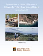 1. Public Access: Edwards Point on the Las Varas Ranch has a long history of informal use by members of the public. Edwards Point has also been planned for 30 years in the County’s Local Coastal Plan for acquisition as a major coastal park. Historic public use includes fishing, hiking, beach walking, swimming, and surfing. This existing public use is threatened by proposals to develop two large estate residential compounds at Edwards Point. These residential estate compounds, including guest homes, walls or fences would lie across routes historically used by the public to gain access to shoreline at this location, effectively blocking public access. In addition, based on similar situations along the eastern Gaviota Coast and at locations such as Broad Beach in Malibu, the real potential exists for new development to use security guards, cameras and other security measure to interfere with or eliminate historic public access to the coast at Edwards Point. Construction of new residential estates at Edwards Point would forever preclude its planned acquisition for a major coastal park.
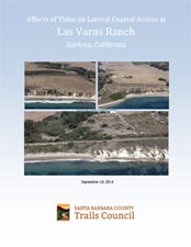 2. Lateral Coastal Access: As part of a development review County and State policies require provision of public access along the shoreline even at high tide. The Las Varas Ranch development project, as proposed, would eliminate existing informal access along the coastal bluff tops. However, the proposed granting of lateral access along the beach would not guarantee the public’s right to passage along the shoreline the majority of the time due to tides. The developer’s proposed lateral coastal access trail easement (i.e., California Coastal Trail) is located along busy US Hwy 101, almost ½ mile from the shoreline; not exactly a lateral beach access trail. This paper explores the affects of tides on lateral coastal access at Las Varas Ranch. Download our report: Affects of Tides on Lateral Coastal Access at Las Varas Ranch
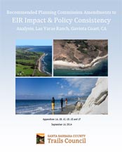 3. Recommended Amendments: The Trails Council has written a set of draft amendments that it recommends be adopted by the County of Santa Barbara Planning Commission. Our report is organized into appendices 1A through 1F and includes recommended findings of significant impacts to Recreation, Land Use, Policy Inconsistencies, and Agriculture/Grazing. Also included is information on the role of a conservation easement to mitigate multiple impacts and examples of specific plans use in rural areas. Download our report: EIR Impact & Policy Consistency Analysis, Las Varas Ranch
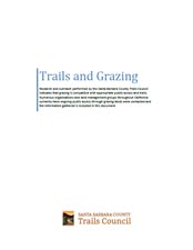 4. Cattle and Grazing: Research and outreach performed by the Santa Barbara County Trails Council indicates that grazing is compatible with appropriate public access and trails. Numerous organizations and land management groups throughout California currently have ongoing public access through grazing lands were contacted and the information gathered is included in this document. To date, all organizations contacted have reported negligible issues between the public and grazing operations. Download our report: Compatibility of Trails and Livestock at Las Varas Ranch and Elsewhere
More about the Las Varas Ranch Project
The Santa Barbara County Planning and Development Department has posted the Revised Final Environmental Impact Report for Las Varas Ranch Parcel Map and Lot Line Adjustments documents here:
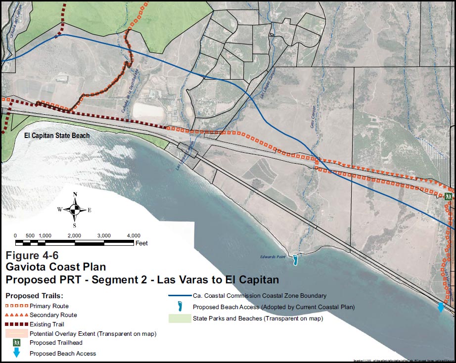
Las Varas Ranch Developers propose California Coastal Trail sited north of 101 Hwy, outside the coastal zone and a half mile from the ocean.
 1% for the Planet is about coming together, and they believe that forging connections between businesses and nonprofits is a critical aspect of solving the global environmental challenges we face. The nonprofit sector fills a unique and critical role, and the 1% for the Planet model and mission are focused on unleashing the incredible power that is possible when businesses support and engage with these impactful nonprofits.