
The concept of sustainability for outdoor recreation is a very broad topic that covers environmental, social, and economic issues. When narrowed to defining sustainable trails several topics come into play.
- Does the trail have a positive impact on the environment and the community?
- Is the trail valued and supported by the local community?
- Is the trail robust, durable and fit for the intended purpose?
- Does the trail require minimal maintenance?
- Is it acceptable to property owners and/or land managers?
- Does it comply with USDA Forest Service standards for trail construction and maintenance?
- Does the trail have long-term appeal for outdoor recreation?
A sustainable trail will lead users to desired locations while avoiding wet areas, steep slopes, critical habitats, and other culturally or environmentally sensitive areas.
|
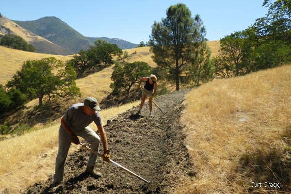
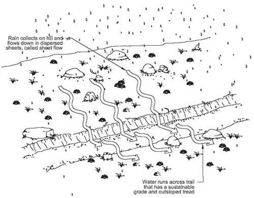
In Santa Barbara County erosion is the number one problem for sustainable trails. It damages trails, is expensive to repair and diminishes the user experiences. Existing trails that collect water or channel water are both environmentally and economically unsustainable and require a concerted effort by land management agencies and volunteer groups to minimize or correct the problems as they arise. Following USDA Forest Service standards for planning and design of new trails helps to ensure that even in the most challenging terrains trails will be sustainable to the highest degree possible.
Ideally, it is best to site trails on a side-slope and follow the natural contour of the land to shed water and be most sustainable. However, site-specific geology or the provision of a narrow trail corridor easement creates challenges that are not always addressed in textbook solutions. In most situations, a 40-foot wide trail corridor will give the trail planner room to create a sustainable trail. As the corridor narrows the sustainability challenges increase and projects with trail corridors of 20 feet wide or less field conditions may partially hinder achieving USDA Forest Service trail design standards.
Gentle Out-slope of at Least 2%,
Whether a trail follows a fall-line (in the direction of the slope), flat ground, or along the contour (perpendicular to the slope) users will leave the trail when it becomes eroded or wet, or when the trail does not meet their needs or expectations. When users leave the trail tread, they widen it, create braided trails, and create social trails. Restoration of existing trails and the design of new trails use four essential elements for creating high-quality sustainable trails.
1) Out-slope: A trail’s tread should always be slightly higher on the uphill side so that water can easily drain off. A gentle outslope of at least 2%, preferably 5%, is recommended. Trails without this out-slope catch, hold, and channel water, helping erode and destroy the trail. Proper out-slope encourages water to sheet across and off the trail.
Trail Slope Half of Side Slope
2) Proper Grade: When applied to trails, there are 3 aspects of grade to take into consideration:
- The average grade of the trail overall should not exceed 10%. A lower average of 8% is better and preferred.
- Limit the maximum grade, the steepest parts, to 20% and only for short sections less than 50 linear feet. Limits on steepness are site-specific and depend on factors such as soils, rainfall, geology, and width of the easement.
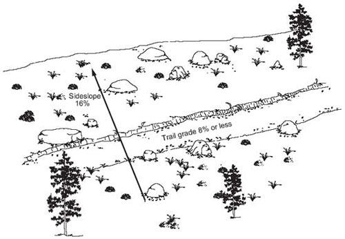
- A trail’s grade shouldn't exceed half the grade of the side-slope. In other words, a trail should be less than half as steep as the slope it traverses.
- New trails that are required to meet accessibility standards have their own set of allowances for change in grade. The running slope shall be 1:20 (5%) or less for any distance with the following exceptions:
- 1%-8.3% for up to 200 ft
- 3%-10% for up to 30 ft
- 1%-12% for up to 10 ft
No more than 30 percent of the total trail length shall exceed a running slope of 1:12 (8.33%). It is typical for sections of a trail to be designated as accessible even when the whole trail does not meet all the standards for accessibility.
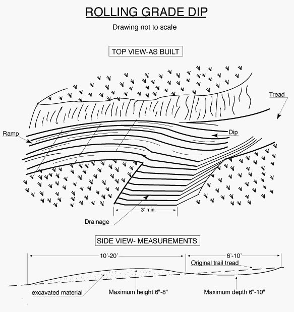
Rolling Dips are Subtle
3) Rolling Dips: Rolling dips are little drops in a trail that force water to drain at the low spot. Rolling dips are subtle depressions, as short as 10’ in length and as much as 20-25’ in length that prevents water from gaining volume, momentum, and erosive power. They also should be frequent – every 20’ to 50’ depending on soil and water conditions. Rolling dips also make a trail more enjoyable, providing variety and relief. Historically, water bars have been used to control water runoff, but they are no longer promoted for modern sustainable trail design.
4) Grade Reversals: A grade reversal is a change in grade from a downhill grade to an uphill grade over a much longer distance, typically long enough so that you are going from a downhill section of trail to an uphill one. They especially work well if the slope is such that you’ve in essence divided sections of the trail into smaller “watersheds” with the water from each flowing off the trail with no need for dips.
Building sustainable trails decrease time and money demands while increasing user enjoyment and resource protection.
The Trails Council provides guidance and effective management for trail planning, construction, and maintenance projects for public agencies and private landowners. We comply with USDA Forest Service standards for trail construction and maintenance.
Recent Projects
| • Ellwood Mesa Coastal Trails/Habitat Restoration | Planning/Design |
| • Baron Ranch Trail | Los Padres National Forest | Planning/Design/Construction |
| • Baron Ranch Trail | Santa Barbara County | Planning/Design/Construction/Habitat Restoration |
| • Franklin Trail | Los Padres National Forest | Planning/Design/Construction |
| • Franklin Trail | Santa Barbara County | Planning/Design/Construction/Habitat Restoration |
| • Goleta Butterfly Grove Trails | Maintenance |
| • Midland School Ranch Trails | Planning/Design/Construction |
| • Rice Ranch Trails | Planning/Design/Construction |
| • Skytt Mesa Trail | Planning/Design/Construction |
| • Lake Los Carneros Park Trails | Restoration/Maintenance |
| • Jesusita Trail Reroute | Restoration/Maintenance |
| • Rattlesnake Trail Repair | Restoration/Maintenance |
| • Gaviota State Park Trails | Maintenance |
Reference Links
- USFS Trail Construction and Maintenance Notebook
- National Best Management Practices for Water Quality Management on National Forest System Lands
- Handbook For Forest, Ranch & Rural Roads
- Part X, Upslope Erosion Inventory And Sediment Control Guidance
- IMBA Trail Building and Design
- American Trails Design and Construction
 1% for the Planet is about coming together, and they believe that forging connections between businesses and nonprofits is a critical aspect of solving the global environmental challenges we face. The nonprofit sector fills a unique and critical role, and the 1% for the Planet model and mission are focused on unleashing the incredible power that is possible when businesses support and engage with these impactful nonprofits.