

Phase III | Los Padres National Forest Segment
Taking the Franklin Trail to the crest of the Santa Ynez Mountains (Phase III) will add 2.7 miles of trail infrastructure to one of Carpinteria’s most popular places to enjoy nature-based recreation. Upon completion, the multi-use trail will provide hikers, equestrians, mountain bikers, trail runners, and other trail users with a direct route from Carpinteria to the Santa Ynez River. All in all, extending the local trail will result in more reasons for community members to use this free and easily accessed open space for a range of benefits including health, fitness and overall wellness.
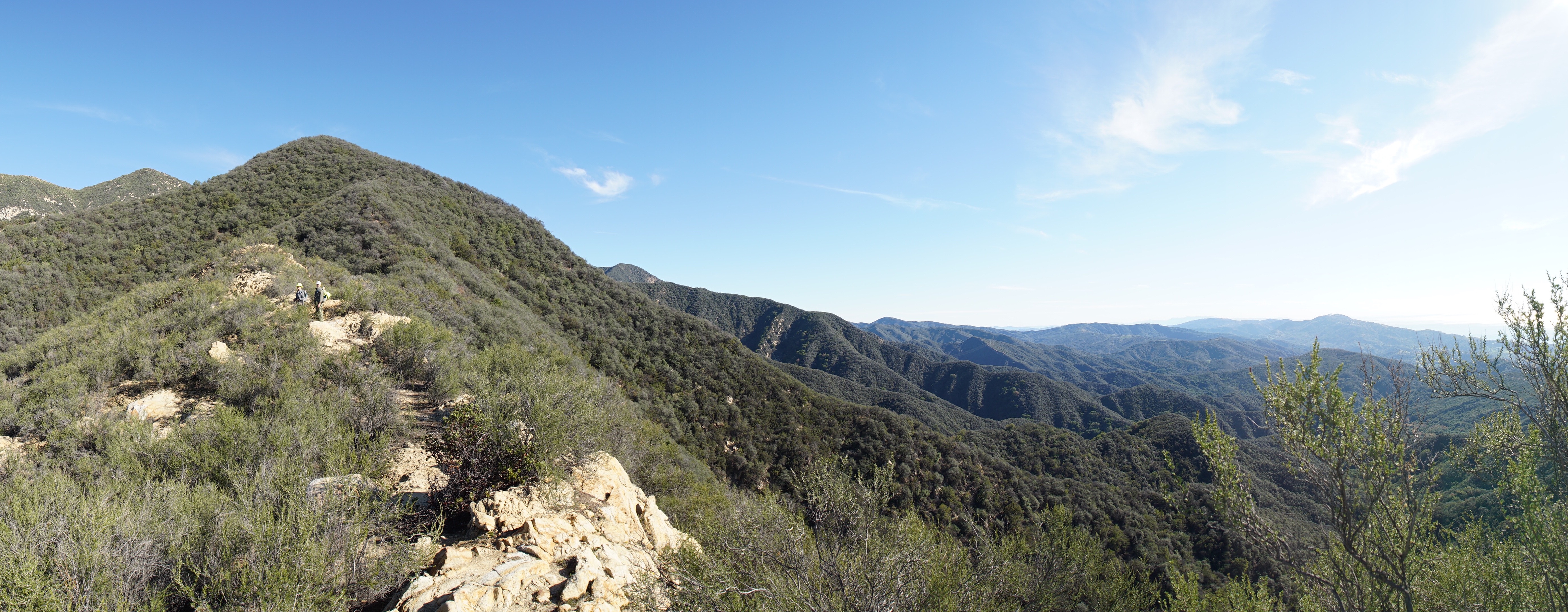
 The Santa Barbara County Trails Council (Trails Council) is working to complete almost three miles of single-track trail (with a 2000 foot elevation gain) through the Los Padres National Forest to the crest of the Santa Ynez Mountains. This section of the 8 mile long trail cuts through mountainous chaparral offering panoramic views of the islands, coastline and valley floor.
Access to the Los Padres National Forest along the historic Franklin Trail, built in 1913 by the US Forest Service, was lost 40+ years ago when permissive use over private properties ceased to exist due to the changing character of land ownership and the intensification of agriculture in the valley. With widespread support from community members we are reclaiming a 2.7 mile long portion of the 7.9 mile long trail.
Collaborative Initiative
 The Trails Council is collaborating with the US Forest Service, the Friends of Franklin Trail, Montecito Trails Foundation, Los Padres Forest Association and the Santa Barbara Sierra Club Group to extend the modern day Franklin Trail across its historic route through the forest.
The Project
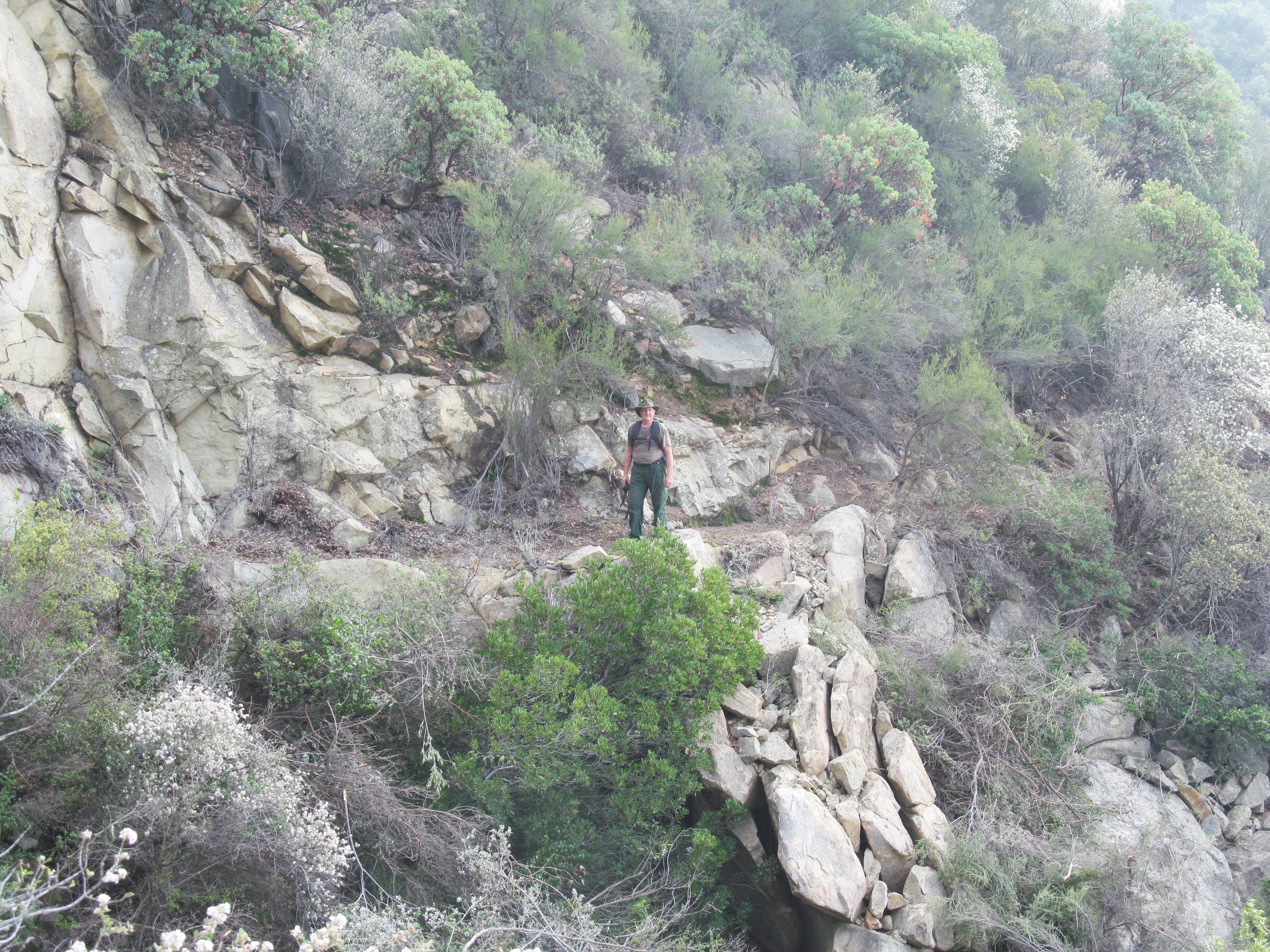
The Phase III of the Franklin Trail Project is a 2.7 mile section of trail that is wholly within Los Padres National Forest. Having no maintenance since it was closed in the 1970s, the upper part of the Franklin Trail is clogged with brush, much of it decayed material that has fallen down onto the trail and creating an almost impenetrable thicket. Additionally, the trail is steep and washed out in places, and will require extensive hand work to reclaim the trail.
Timeline
In 2015 we initiated the biological, archeological, and recreation field surveys and reports that will be compiled into a draft environmental report that is reviewed by the US Forest Service. Upon approval of the environmental documents we will reconstruct the historic trail with completion anticipated in late 2016 or early 2017.
The Route
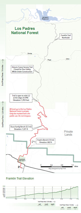
Map by Ray Ford
With the trailhead near Carpinteria High School, the Franklin Trail winds around the school, track field, and adjacent orchards where the trail begins a steady climb and switch backs will take you up Franklin Canyon while rising into the foothills of the Santa Ynez Mountains with magnificent ocean views. Leaving the single track the trail follows a dirt road alongside several ranches with a mixture of well developed coastal scrub and mixed chaparral. The first five miles follow easements provided by private land owners to reach the edge of the Los Padres National Forest. The Phase III portion of the trail begins at 1,700 feet offering vistas of the Santa Barbara Channel, the islands and the Carpinteria valley.
The top of the trail is at 3,720 feet above sea level and 7.9 miles from the trailhead. At this junction, the Franklin Trail joins the segment of the trail on the north side of the mountains where it goes past Alder Creek and runs down to Jameson Lake joining miles of backcountry trails such as those in the Dick Smith and Sespe Wilderness Areas. To the west is the link to the network of Front Country trails in Montecito and Santa Barbara. A PDF version of the trail map can be downloaded
Why Is This Important
Just north of Carpinteria, the Los Padres National Forest provides a network of hiking, biking and equestrian trails that wind through the chaparral covered foothills. For many years, there has not been a direct link from the Carpinteria valley floor to any of these mountain trails. Reopening the trail will provide residents of Carpinteria and neighboring communities an opportunity to participate in aspects of nature-based recreation that has not been possible for decades. As a multi-use trail the Franklin Trail is open to the safe shared use by everyone.
The Outcome
- Reclaim historic trail that has been closed for over 40 years
- Expand free outdoor gym for health, fitness and overall wellness
- Add 2.7 miles of trail to enjoy nature-based recreation
- Provide trail users with a direct route to the Santa Ynez River
- Increase recreational opportunities for the whole community
The Budget
The trail restoration project is divided into phases that will require approximately $110,000 to complete:
- Environmental Reports/Review:...$26,400
- Trail Planning/Review:.....................$4,300
- Construct 2.7 Mile Long Trail:.......$60,000
- Fundraising:......................................$4,500
- 5-Year Maintenance Reserve............$4,800
GRAND TOTAL......................................$100,000
A single page project summary is available.
How to Give to the Campaign
Thank you for considering a gift to the Franklin Trail Fund. All gifts are tax deductible to the full extent allowed by law. You will receive a written acknowledgement of your gift in the mail.
Donation Levels
- Trail Enthusiast........................ $25
- Trail Guide................................ $35
- Trail Advocate........................... $50
- Trail Partner.............................$100
- Trail Builder.............................$500
- Trail Blazer............................$1,000
- Trail Guardian.......................$5,000
We need community support to finance this ambitious project. To donate online click the green button or download our pledge form to mail a check. All donations are tax deductible to the extent provided by law. Donations of $1000 or more will be recognized on the trail kiosk
For more information call Executive Director, Mark Wilkinson, at 805.708.6173
Fly Over Video for Phase III
To see how challenging it will be to re-open the Forest Service part of the Franklin Trail, check out this video by Ray Ford with the help of a GoPro camera attached to the outside of the helicopter. http://vimeo.com/84875487
 1% for the Planet is about coming together, and they believe that forging connections between businesses and nonprofits is a critical aspect of solving the global environmental challenges we face. The nonprofit sector fills a unique and critical role, and the 1% for the Planet model and mission are focused on unleashing the incredible power that is possible when businesses support and engage with these impactful nonprofits.