
Discover, Explore, Connect Santa Barbara County's Coastal Trails
A rich past dating back thousands of years can be experienced today in following the footsteps of history on the California coast. Three trails weave together along the original trade routes that connected oceanside settlements of the Chumash people: the Juan Bautista de Anza National Historic Trail, the California Coastal Trail, and the route used by people walking the California Missions Trail. The culture, history, and outdoor recreation found along these trails in Santa Barbara County, California, offers a glimpse into a fascinating past while enjoying the breathtaking scenery of the Coast.
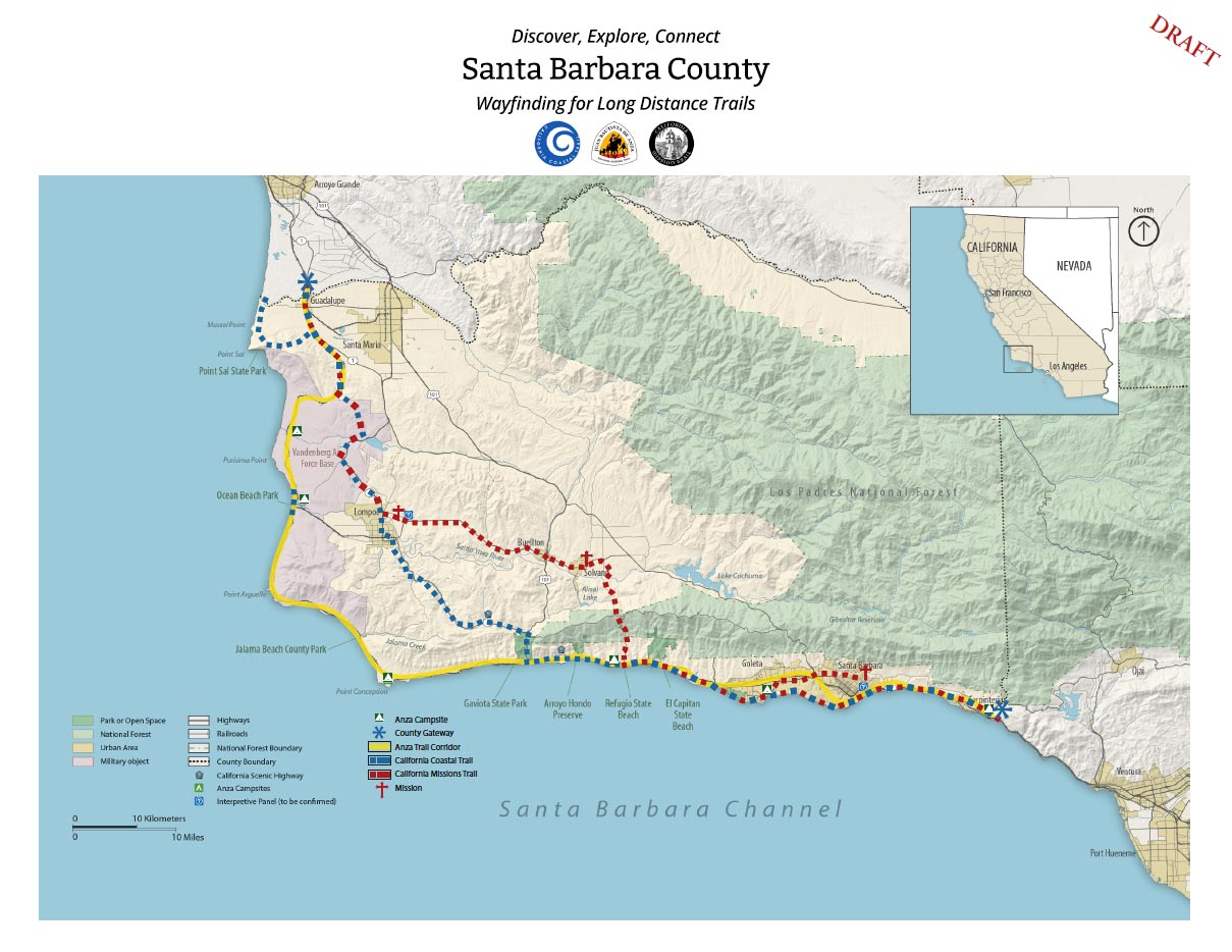
A coastal recreation experience for trails established centuries ago by the Chumash Indians in present day Santa Barbara County. The routes parallel segments of the Juan Bautista de Anza National Historic Trail, the California Coastal Trail, and the California Missions Trail
Discovering and enjoying these trails, however, is complex due to the distance covered, the interrupted sequencing of the trail, the multiple number of properties crossed, and the number of government agencies with jurisdiction over segments of the trail. For the layperson, it is hard to discern where these trails are, where they share the same footprint, where they diverge, and where they connect. The goal of this project is to develop and recommend a uniform wayfinding plan that addresses the unique situation when one trail in Santa Barbara County is shared cooperatively. The wayfinding component will incorporate recommendations for marking trail segments that share multiple designations including the Juan Bautista de Anza National Historic Trail, the California Coastal Trail, and the California Missions Trail. The wayside exhibit component will include interpretive signage at strategic sites that will help visitors engage with the history of the Chumash, the legacy of the Juan Bautista de Anza National Historic Trail, the origins of the three Missions in the County, and the beautiful resources of the California Coast.
The vision for the project is:
An enjoyable coastal recreational trail experience in Santa Barbara County that is easily discovered and explored by local, national, and international visitors alike.
Primary goals for this effort are to:
Create a graphic identity system based on the historical Chumash trading route for the Juan Bautista de Anza Historic Trail, the California Coastal Trail, and the California Missions Trail in Santa Barbara County that cross multiple communities in Santa Barbara County. Categories include: Gateway kiosks, interpretive panels, directional signs and wayfinding markers.
- Create multi-trail graphic identity system.
- Develop a countywide digital trail map.
- Consolidate, unify & simplify existing wayfinding & signage systems.
- Encourage visiting, exploring and appreciation of natural environment.
- Improve community health by encouraging walking and bicycling.
- Preserve scenic beauty of the coastline in Santa Barbara County.
- Create a platform for governmental & other groups to collaborate.
- Identify project funding for wayfinding elements & informative brochure.
The challenge and opportunity for this project is to create a platform for governmental and non-governmental organizations to collaborate on a complex countywide infrastructure issue that is acknowledged, but unlikely to be addressed comprehensively due to lack of resources available to the individual entities. It is hoped that the resulting report will be recommended for adoption by multiple government agencies as a way to improve the recreational experience along of one of the County of Santa Barbara’s most valuable recreation resources.
 The first phase of this multi-phase project is being funded by the Trails Council and a hands-on technical support grant from the National Park Service, Rivers, Trails and Conservation Assistance Program. Components of the first phase include:
- Research and Analysis
Deliverables: Project Schedule, Research Report, Problem Statement, Examples - Strategy/Design Brief
Deliverables: Wayfinding Strategy, Design Goals and Objectives, Outline of Sign Types - Programming
Deliverables: Draft Sign Location Plans, Draft Message Schedules, Preliminary Budget
Additional phases, Design, Story Telling, and Implementation will be added as funds become available.
Community Support
There are many dimensions to this project and a long time line. We are looking for community members who want to volunteer for this monumental project. Given the scope of the project we can support a wide range of interests. We have openings in the following committees.
- Technical Committee: Print and digital mapping, GIS, Field surveys, Message schedules and locations
- Communications Committee: Branding, Marketing, Outreach, and Tourism
- Content Development Committee: Researching and writing natural, cultural, historical stories associated with the trails
Please contact us to join the team or learn more about the project.
 1% for the Planet is about coming together, and they believe that forging connections between businesses and nonprofits is a critical aspect of solving the global environmental challenges we face. The nonprofit sector fills a unique and critical role, and the 1% for the Planet model and mission are focused on unleashing the incredible power that is possible when businesses support and engage with these impactful nonprofits.