
Proposal for the Baron Ranch Trail Expansion
Posted by Mark Wilkinson on Jan 1, 2016 in Baron Ranch, Projects | 0 comments[2021 UPDATE] The trails proposed over a decade ago are now open seven days a week for all trail users except our canine friends. More information is available at the Explore Santa Barbara County website.
Spring 2016
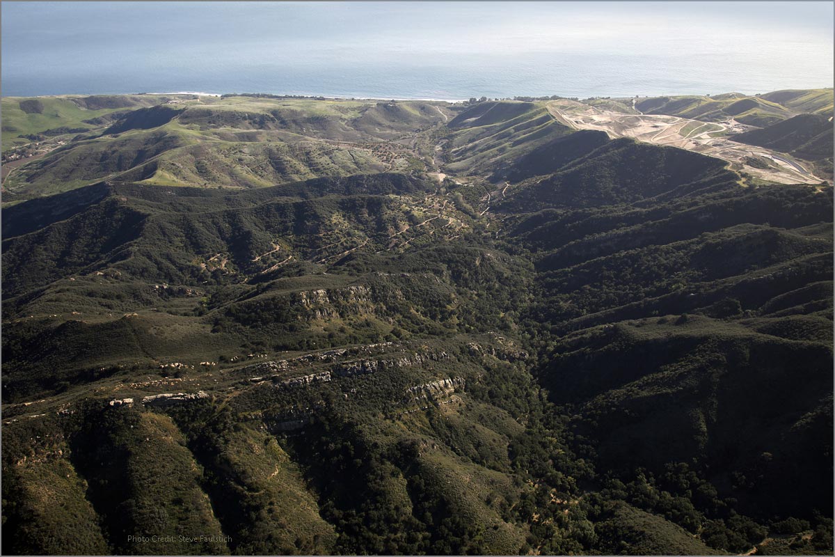
Baron Ranch is a 1,083-acre ranch owned by Santa Barbara County (County) and is managed by the County Public Works Department’s Resource Recovery & Waste Management Division. The primary use of Baron Ranch is currently agricultural, including avocado and cherimoya orchards. However, 50 acres of the ranch has been restored with native plant communities as a part of the biological mitigation program for the Tajiguas Landfill Reconfiguration Project and partial mitigation for the Tajiguas Landfill Expansion Project. Habitat restoration activities have included creek restoration, planting of native riparian, oak woodland, coastal sage scrub and chaparral habitats, and relocation from Pila Creek to Arroyo Quemado Creek (Creek) of the California red-legged frog, a species listed as threatened under the Federal Endangered Species Act (Padre Associates, Inc. 2015). Approximately 30 acres of the ranch, including portions of the Creek, are proposed to be placed in a conservation easement upon completion of the restoration activities.
The existing Baron Ranch Trail (Trail) provides an approximately 6-mile loop from the trailhead at the Calle Real frontage road that parallels the north side of U.S. Highway 101. The existing trail was completed and opened to the public in December 2010. This Trail follows existing ranch roads throughout much of its course. The lower reaches of this trail traverses existing orchards for over 1 mile and then enters relatively undisturbed native habitats in its northern reaches. This Trail is generally located east of the Creek and is currently use-restricted to foot traffic only; mountain bikes, dogs and equestrians are currently prohibited, although trail operation guidelines permit such restrictions to be reviewed and reconsidered over the long-term (Santa Barbara County Board of Supervisors, Resolution 09252; 9/15/09). The trail is currently open for use on Saturday, Sunday, and Monday (dawn to dusk); however, on March 15, 2016, the County Board of Supervisors adopted a resolution to acknowledge the modified location and use of the County-owned portion of Baron Ranch Trail.
Project Proposal
With assistance from the Santa Barbara County Trails Council (Trails Council) and in coordination with the Santa Barbara County Community Services Department, Parks Division and the County Public Works Department, we propose to construct and maintain a 1.35-mile realignment of the existing Baron Ranch Trail, from the eastern side of the Creek to its western side via a bridge spanning the creek, reconnecting with the existing trail at an at-grade crossing. The Project includes the entire trail segment within the County’s jurisdiction, extending northward and connecting with the trail segment in the US Forest Service LPNF boundary. Improvement of visitor and trail user amenities (e.g., provision of a vehicle turnaround area, designation and interpretive signage, and kiosk with trail information), installation of minimal fencing along a portion of existing ranch roads on the west side of the Creek, and restoration of native habitat disturbed during Project implementation is also proposed. These actions collectively comprise the Baron Ranch Trail Realignment Project (Project). The proposed Project is located off Calle Real on the Gaviota Coast in Santa Barbara County, California, approximately 2.5 miles northwest of Refugio State Beach
The proposed Project requires a Coastal Development Permit, with a public hearing to permit:
- Construction of a vehicle turnaround to accommodate all trail users (including trucks with horse trailers, within a disturbed area and existing residential access road) along Calle Real within County right-of-way. Turnaround improvements include grading with a finished surface of a compacted road base. Graded slopes would be hydro-seeded with appropriate species for the area;
- A new 65-foot-long by 8-foot-wide prefabricated bridge with a non-slip deck surface suitable for all users, upon creek-side concrete abutments at the canyon entrance of Arroyo Quemado; and
- From the bridge crossing, relocation of the lower reach of the existing Baron Ranch Trail from the east to west side of the Creek along an existing ranch road where it would reconnect with the existing Trail approximately 1.2 miles upstream and north of the agricultural production area, crossing the Creek at-grade at a location with shallow slopes; and,
- Increased usage of the entire Baron Ranch Trail as a multiple-use trail for equestrians, mountain bikers, hikers, dog walkers, and trail runners during the daylight hours, seven days a week.
The southern reach of the proposed trail realignment would follow the Baron Ranch access road and existing Trail route for approximately 1,850 feet from the proposed turnaround, northwest to the newly proposed bridge across the Creek. The proposed realigned Trail would extend from the new bridge near the south end of Baron Ranch, along existing dirt roads west of the Creek, reconnecting with the existing trail approximately 1.2 miles to the north and extending to the Los Padres National Forest (LPNF) boundary. County restoration of riparian and oak woodland habitat west and east of the Creek would be undisturbed. Approximately 200 sf of riparian habitat restoration would be provided where needed due to the installation of the bridge. Separation of recreational uses from agricultural uses would be realized by this realignment, with the riparian corridor serving as the boundary. The new Trail would then reconnect to the existing Baron Ranch Trail, including the segment within the LNPF that extends to the ridgeline of the Santa Ynez Mountains.
The proposed Baron Ridge Trail would enhance non-motorized public access across County-owned land and to an area of LPNF that is currently inaccessible via any established route. This combined County-LPNF Trail would be one of only two Front County trails to provide access to LPNF land in the 26-mile reach of the LPNF west of California State Route 154. The Baron Ridge Trail would provide connections to the West Camino Cielo within LPNF, and to Gaviota State Park trails to the west, creating greater than 13 miles of trail system across County, state, and federal lands.
The proposed Trail would replace the existing lower reaches of the Trail located east of the Creek. The County proposes to construct and maintain this Trail with funding support from the Trails Council for ongoing trail maintenance activities.
While trail use is currently restricted to pedestrian-users, joint trail operation under the County and LPNF as a multiple-use trail is proposed. User groups are anticipated to include hikers, mountain bikers, equestrians, dog walkers, and trail runners. Opening of the trail for multi-use by these groups has been endorsed by the Board of Supervisors, including opening the trail for use seven days a week during the daylight hours between 8:00 AM and sunset upon.
Project Components
The proposed Project would include installation of a new 65-foot diameter vehicle turnaround (area of approximately 3,320 sf), a bridge, gates and fences, small kiosk, wayfinding signs, interpretive signs, minor trail improvements, and erosion control. Existing dirt ranch roads would be converted to multi-use trails. Best Management Practices (BMPs) such as erosion control techniques, revegetation, and living fencing such as poison oak and blackberry to control access, would be implemented to minimize potential environmental effects of all trail improvements on adjacent sensitive habitats. Vehicle and trailer parking would be provided by existing road shoulders within existing County right-of-way at the end of Calle Real and located immediately east of the Baron Ranch entrance gate.
Lower Baron Ranch Trail Budget
The trail project a bridge across Arroyo Quemado Creek, trail realignment to the west side of the Ranch, new entry gates and fencing, and a turnaround feature at the end of Calle Real for school buses and equestrian trailers.
Project Budget for Construction (portion allocated to Trails Council)..........................................$365,000
So far we have raised $317,000 from community members, County of Santa Barbara, Sierra Club, REI CoOp, Santa Ynez Band of Chumash Indians, STEL, and UCSB Coastal Fund.
How to Give to the Campaign
Thank you for considering a gift to the Baron Ranch Trail Fund. All gifts are tax-deductible to the full extent allowed by law. You will receive a written acknowledgment of your gift in the mail.
Donation Levels
- Trail Enthusiast........................ $25
- Trail Guide................................ $35
- Trail Advocate........................... $50
- Trail Partner.............................$100
- Trail Builder.............................$500
- Trail Blazer............................$1,000
- Trail Guardian.......................$5,000
We need community support to finance this ambitious project. To donate online click the green button or download our pledge form to mail a check. All donations are tax-deductible to the extent provided by law.
All donations in 2020 receive a Baron Ranch t-shirt as our thank you. Please include your choice of women's or men's style and the size when donating.

For more information call Executive Director, Mark Wilkinson, at 805.708.6173
Be sure to see the winning photos from our 2017 Gaviota Coast Photo Contest. Also check out the trailer for Gaviota: The End of Southern California. This feature film, selected for the 2017 Santa Barbara International Film Festival, explores one of the most threatened biodiversity hotspots in the world.
 1% for the Planet is about coming together, and they believe that forging connections between businesses and nonprofits is a critical aspect of solving the global environmental challenges we face. The nonprofit sector fills a unique and critical role, and the 1% for the Planet model and mission are focused on unleashing the incredible power that is possible when businesses support and engage with these impactful nonprofits.