

The Last Leg of the Franklin Trail
Posted by Marque on Jan 15, 2014 in Blog | 0 commentsPhase 3 Implementation Begins
With extensive community support the historic Franklin Trail is being re-established in the Los Padres National Forest. Once the last leg is completed it will be possible to hike all the way from Carpinteria to the top of the Santa Ynez Mountains and into the Santa Barbara backcountry. The trail down the backside of the mountains is already open and follows Alder Creek towards Jameson Lake.
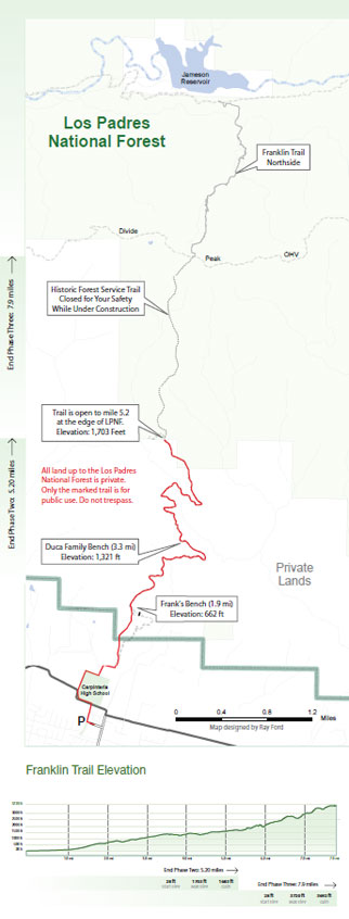
Map by Ray Ford
The Trails Council is spearheading the identification of the route the Franklin Trail took through the Los Padres National Forest several decades ago. The trail was taken off the US Forest Service trail inventory in the late 70's, so for all practical purposes it is considered a new trail project requiring all the pre-construction implementation steps typical of a new trail across National Forest lands.
Trails Council Project Manager Ray Ford is leading a group of volunteers to complete the first stage of the project, however after a flyover and initial trail scouting, it is becoming clear that it will take substantial effort to cut a preliminary trail (p-line) through the dense chaparral.
Friends of Franklin Trail, Montecito Trails Foundation and the Los Padres Forest Association have joined in with the Trails Council to provide ongoing project support. We are in the process of raising $10,000 to cover the cost of a skilled crew to chain saw through two miles of chaparral with the support of community volunteers. All forms of help are appreciated so please contact Ray Ford (805.886.5776) to volunteer for trail work or click on the button to the right to make an online donation.
For more information call Executive Director, Mark Wilkinson, at 805.708.6173
A PDF version of the map can be downloaded
Take a look at a new film recently completed by Larry Nimmer: "The Reopening of The Franklin Trail"
 1% for the Planet is about coming together, and they believe that forging connections between businesses and nonprofits is a critical aspect of solving the global environmental challenges we face. The nonprofit sector fills a unique and critical role, and the 1% for the Planet model and mission are focused on unleashing the incredible power that is possible when businesses support and engage with these impactful nonprofits.